Google Earth's new creation tools let students demonstrate their learning on a map. Tell stories. Share information. Then share it with class!
Google Earth calls itself "the world's most detailed globe."
It's true! Zoom in to anywhere in the world. Tilt to see the elevation and buildings pop out of the ground. Click on locations to gather details.
For years, Google Earth (google.com/earth) has been a fantastic CONSUMPTION tool. Consume visuals and info about the world.
Now, students don't have to just consume with Google Earth.
They can CREATE.
Meet Google Earth creation tools
Google recently added the ability to create Google Earth projects. In these projects, your students can stick pins to the globe, add rich media and detailed information, then present it step-by-step like a story.
Use the new "Projects" button in the left sidebar of Google Earth (the pin on map icon). Here's what you can do:
Placemarks
Click search to add and then "Add to project" in the knowledge card. Add to new project or an existing project. Click "Save." You can also drop a placemark by dropping directly on Google Earth.
Lines and shapes
To create lines: Click draw line/shape button in toolbar. Then, click the globe to draw line with series of points. Press Enter. Give it a title to save to project.
To create shapes: Click draw line/shape to draw a shape too. Then, click on the toolbar and click globe to draw. Add several points to draw the shape. Close the shape by clicking on the first point. Give it a title and save to project.
Street View
Click the yellow pegman to see where Street View is available. Find a line or dot to see Street View and click. Set up the view you want. Click "Capture Street View" to add it to your project.
Slides
Add a full screen slide as an introduction, section break or ending. Click "Add to project" in sidebar and choose "Fullscreen slide". Add a title, description, background color and/or background image.
To see a video on adding features to a map, click here.
Editing a place on the map
Hover over a place in the sidebar and click the pencil to edit. (You can also click "edit" when you create a new place instead of clicking "save".) In the edit menu, you can edit the following for your place ...
- images and videos (upload, image search, YouTube, Google Drive, your photos or URL)
- title
- description (including links, text alignment, bold, italics, lists and more)
- type of info box (small, large or none)
- placemark icon
- view (set how the place appears on the screen manually with altitude, tilt and more; also, set it the way you want on the screen and click "Capture this view")
- line width and color
- shape color and transparency
To see a video on styling the places in your project, click here.
Reorder
Move the items in your Google Earth presentation around by clicking and dragging them into order in the sidebar.
Present
Click the "Present" button to display the project in full screen. Use the arrow buttons to move forward or backward through your project. You'll fly back and forth to the spots in your project.
Using Google Earth in the classroom
These Google Earth creation tools let students tell powerful stories -- and share useful information -- visually on the map.
But what would that look like in the classroom?
Check out the video below to see how a family shared memories, a biologist made a tour of the Hudson River, and a class of students studied how a local lake had been abused.
10 ways to use Google Earth creation tools in the classroom
Want to put the power of these tools in your students' hands? Here are some ideas ...
1. Identify important locations in a story/history
Are you studying a story that has real locations in the real world? Have students drop placemarks in those locations and write descriptions of why they're significant to the story or history.
2. Show the timeline of a person's life
Pick a person from history. A character from a story. Someone a student knows in real life. Plot the 10 most important places in that person's life on a map -- and describe why they're important.
3. Relive a trip
If a student has visited someplace meaningful, have that student drop markers on the most important places and describe them. Add personal photos and videos to make it more vivid. This doesn't rule out students who don't travel, though. They can pick a place they'd like to visit and describe where they'd go!
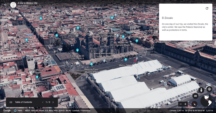
In this short Google Earth project, I share three important stops in my own visits to Mexico City. Click the image to interact with my Google Earth project!
4. Do a "Day in the Life" project
Through an interview -- or by shadowing them -- students can document the normal day-to-day happenings of someone in their community -- or beyond! Students drop pins where that person goes and describes it in the description. If the person shares photos or videos of their day-to-day activities, add them to make it more vivid!
5. Tell a fictional story
Put students' creative capacities to the test! Each placemark in their Google Earth project can be a page in a story. Upload student-created images (scanned, photos, created with digital tools, etc.). Then present them full-screen and tell the story!
6. Do place-based math problems
Geometry. Distance, rate, time. Ratios and proportions. Any of these can come to life when put on a map and connected to real places. Have students crunch the numbers and share them on their own Google Earth projects. Or take it to the next level and ...
7. Do a collaborative class map
Each student can create a placemark on a class map, adding rich details, images, videos and more to their pins. When each student dives deep into his/her own pin, a collaborative "crowd sourced" map becomes very detailed very quickly!
8. Create a supplement to the school newspaper or yearbook
Where did the sports teams compete -- and how did they do? Where have students worked or done internships? Where have students traveled? The newspaper or yearbook staff can create a Google Earth project with those details. Share it in the newspaper or yearbook for others to see!
9. Create a school/district resource about other schools
Provide a map with addresses, important information, events and more for parents and community members. They can use it to see where events are and gather valuable information. Plus, it's a great visual aid to see how far the school's activities reach.
10. Create a "Where are they now?" map
A "Where are they now?" map is great for school alumni to see what they're doing and how far they've gone from home. It can also be used in the classroom to show where people in current events are and what they're doing.
Even more ideas for Google Earth creation tools
These creation tools are similar to another Google product -- MyMaps. The difference? Google Earth is more story-based and more visual.
Check out the MyMaps posts below for even more ideas -- and cross them over to Google Earth's new creation tools!
Question: How could you use Google Earth's new creation tools? How have you used MyMaps in ways that could cross over to these new Google Earth tools? Leave your ideas in a comment below!



[…] 💡 Ideas for use: Creating with Google Earth: 10 activities to try […]
Hi,
About MyMaps we use it in our school trip to Rome to share the places we visit everyday with students’ parents and they can have the places in their phones. With a site where there is the whole material the idea is to create a real and online school trip using MyMaps, Earth, 360 photos, G.Classroom and much more.
Here the Site if you want to have a look.
https://sites.google.com/mataro.epiaedu.cat/romart19/inici?authuser=0
Best wishes,
Manel Trenchs
Sorry I met google earth is amazing.
Hi matt google ear
I like goggle earth because it help me know the world better
I would love to use Google Earth, but their faq page (https://www.google.com/earth/education/faq/) lists it as an “Additional Service” for which we would have to get parental consent. In our district, we aren’t able to turn Earth on only for those who have given consent. How have other districts handled this?
Thanks for pointing this out, Brendan. I’ll be interested to see comments from anyone who has solutions to this, but I’d imagine schools are getting consent for Earth in the same way they do with any others they need COPPA consent for. You can always use it as a teacher in front of class, too. From that same page: “For schools that are unable to grant access to all of their students, we recommend enabling access of Google Earth to teachers in the G Suite Admin console.”
Yea goggle earth is the best
[…] Read the full story by Ditch That Textbook […]